Back when I had a boat(s), one of my favourite birding adventures in the local area was when I would head down either the St Clair River, or Chenal Ecarte (and Johnston Channel) to Lake St. Clair. The St. Clair River has a myriad of channels in its delta, divided by the Michigan and Ontario border.
 |
| Dark Bend on the Chenal Ecarte |
 |
| Johnston Channel |
There was lots of waterfowl and other waterbirds to see. Redhead ducks were regular sights in early summer, as they nested in the area--uncommon this far south. Unfortunately in later years, phragmites took over and made things difficult to see.
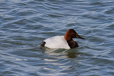
Even Canvasback could be found on rare occasions in summer.
 |
| Common Gallinule family |
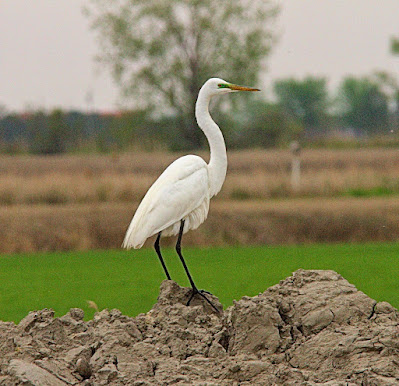
Lots of heron types were seen from Great Blue to Great Egret, Green Heron, and Black-crowned Night-Heron.
Back during the second breeding bird atlas data-gathering period, arrangements were made to scour the waterways in the Ontario portion, including the channels between the main islands of Walpole, St. Anne's, Squirrel, Bassett and Seaway. We turned up some good data!
 |
Hopefully during this third atlas, arrangements can be made to see what breeding birds are present.
 |
| Terminus of Johnston Channel at Lake St. Clair |
This brings me to an interesting story, more historical in nature. The St Clair River delta was a bottleneck for shipping back in the 1800's, as there were three main channels in the delta. The south channel was best suited for shipping, but at its outlet on Lake St. Clair, it was "bendy" and shallow and had to be dredged.
 |
| Light at head of Seaway Island |
Ships travelling from the upper lakes to Lake Erie and beyond had to travel this long route through the St. Clair River, Lake St. Clair, Detrioit River and into Lake Erie.
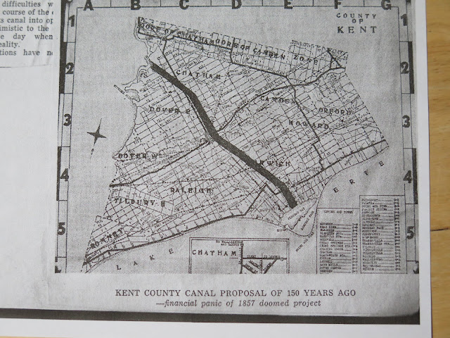
Back in early 1857, there was a grand scheme to to create a ship canal starting at the Chenal Ecarte south of Wallaceburg and ending up at Rondeau Bay. This would cut off the route by many miles!
The basic route was to follow the Chenal Ecarte (SnyeRiver) to its lower reaches and then a canal was to be dug to the Thames River at Chatham, connecting with McGregor Creek, then another canal dug down to Shrewsbury.
A meeting was called by several key figures in the plan, to be held in Chatham. A lawyer in the city, R. S. Woods, detailed the plan where the route would follow the Chenal Ecarte, then through a dredge cut across Dover into Chatham, thence up a dredged-out McGregor Creek, then another cut down to Rondeau Bay. The estimated cost was 1.5 million dollars and would cut about 95 miles off the current ship route.
Of course ships were much smaller then, so perhaps it may have been reasonable.
Various townships from Sombra to Harwich, contributed to the fee for forming a charter. As well, many Boards of Trade from Chicago to Toronto endorsed the plan.
Other interests also thought of a canal from the mouth of the Thames to Two Harbours at Wheatley, but that never gained much interest.
In the meantime during the same year, other interests from the Detroit area, developed a plan to dredge the mouth of the St. Clair River and Lake St. Clair. The St. Clair Flats Canal was eventually dug.
Financial capital was never found, especially when the money market experienced panic in 1857. By the time that stabilized, the Civil War broke out, again blocking any interest in the project.
After the Civil War, Mr Woods found that there was little interest in the project, especially since The St. Clair Flats Canal and the Lake St. Clair Channel had come to fruition.
Of course, even more improvement to the water route through the St. Clair River delta were seen with the digging of the Cut-off Channel. Seaway Island was formed from the spoils of this project, opened in the early 1960's.
Just imagine the undertaking that this cross-country canal would entail! The infastructure needed would be imense! There would be difficulties along the way with regards to drainage, re-aligning roads, building bridges, etc. It was mentioned in the article I read, that difficulties would have been had digging through the "ridge"(or Blenheim morraine), around Blenheim.
The total length of the canal was to be about 65 miles, and the estimated drop to Lake Erie was 33 feet.
Just thought this story would be interesting to some readers, as we await the arrival of spring.
Here is a photo copy of the proposed route:


Great write up, Blake.
ReplyDelete